FlashPoints 3.0

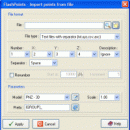
FlashPoints is a tool for creating and managing points Groups (topographic points for example). FlashPoints allows you to : * import/export points coordinates from and to a file * create points and their attributes 'Number', 'Elevation' and 'Description' by clicking * modify the points elevation * modify the height and rotation of the attributes * create points on existing entities * create the table of the coor ...

Author DeliCAD
License Demo
Price $70.00
Released 2016-02-18
Downloads 107
Filesize 3.94 MB
Requirements
Installation Install and Uninstall
Keywords autocad, cad, dxf, xls, excel, gps, xyz, nxyz, points, import, cogo, survey, coordinates, gis, topography
Users' rating
(2 rating)
FlashPointsCADWin2000, Windows XP, Windows 7 x32, Windows 7 x64, Windows 8, Windows 10, WinServer, WinOther, Windows Vista, Windows Vista x64
FlashPoints gps - Download Notice

Using FlashPoints Free Download crack, warez, password, serial numbers, torrent, keygen, registration codes, key generators is illegal and your business could subject you to lawsuits and leave your operating systems without patches. We do not host any torrent files or links of FlashPoints on rapidshare.com, depositfiles.com, megaupload.com etc. All FlashPoints download links are direct FlashPoints full download from publisher site or their selected mirrors.
Avoid: gps oem software, old version, warez, serial, torrent, FlashPoints keygen, crack.
Consider: FlashPoints full version, gps full download, premium download, licensed copy.

FlashPoints gps - The Latest User Reviews

Most popular CAD downloads

TransLT

15.0 download

... database. TransLT is aimed at specialists who use GPS technology to perform geodetic works. The program interface is intuitive, easy to use, the data can be imported from txt or ...

GPS Utility

5.51 download

GPS Utility is an easy-to-use application that provides management and manipulation of GPS information. You can use it to transfer data to/from a GPS receiver and store the data in PC files ...

5 award

Mobile Atlas Creator

2.2.1 download

... source (GPL) program which creates offline atlases for GPS handhelds and cell phone applications like TrekBuddy, AndNav ... a large number of different (mobile) applications and GPS handhelds: AFTrack (Symbian) AlpineQuest (Android) AndNav (Android) BackCountry ...

Mobile Atlas Creator for Mac OS X

2.2.1 download

... source (GPL) program which creates offline atlases for GPS handhelds and cell phone applications like TrekBuddy, AndNav ... a large number of different (mobile) applications and GPS handhelds: AFTrack (Symbian) AlpineQuest (Android) AndNav (Android) BackCountry ...

GPI to GPs converter

1.3 B013000 download

... Garmin POI Loader) to Google Earth (KMZ) or GPS compatible format (GPX) in a few steps. With GPI to GPs converter you are able to transform from GPI to GPs. Download your waypoints from your GPS or ...

NemaStudio

1.36.6465.25714 download

... of various nautical instruments and target objects including GPS, AIS and Radar. All instruments, targets and ports ... that you can have NemaStudio to simulate: ยท GPS (GLL, RMC, VTG, ZDA, GGA, GSA, GSV, XTE, ...

IPaNema

1.1.0 download

... be used to make received NMEA data (like GPS streams) available to any or all clients on ... be used to make received NMEA data (like GPS streams) available to any or all clients on ...

Engauge Digitizer for Windows

12.0 download

... but you do not have an odometer or GPS unit. However, you do have a map. Nice Features: * Automatic curve tracing of line plots * Automatic point ...

Engauge Digitizer for Mac OS X

12.0 download

... but you do not have an odometer or GPS unit. However, you do have a map. Nice Features: * Automatic curve tracing of line plots * Automatic point ...

Engauge Digitizer for Linux

12.0 download

... but you do not have an odometer or GPS unit. However, you do have a map. Nice Features: * Automatic curve tracing of line plots * Automatic point ...