3DFieldPro 4.6.7.0

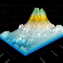
3DFieldPro, developed by Vladimir Galouchko, is a powerful software tool designed for creating stunning 3D visualizations from 2D data. With its intuitive interface, users can easily transform complex datasets into captivating 3D maps, enhancing data interpretation and presentation. The software supports various data formats and offers customizable visualization options, making it ideal for professionals in fields like geology, environmental science, and engineering. Elevate your data analysis w ... ...

Author Vladimir Galouchko
License Demo
Price FREE
Released 2024-08-13
Downloads 1230
Filesize 6.20 MB
Requirements
Installation Instal And Uninstall
Keywords Plotter, Plot, data visualization, Mapper, Map Creator, mapping software, Create
Users' rating
(9 rating)
3DFieldProEditorsWindows 11, Windows 10 64 bit, Windows 8 64 bit, Windows 7 64 bit, Windows Vista, Windows XP 64 bit
3DFieldPro map files - Download Notice

Using 3DFieldPro Free Download crack, warez, password, serial numbers, torrent, keygen, registration codes, key generators is illegal and your business could subject you to lawsuits and leave your operating systems without patches. We do not host any torrent files or links of 3DFieldPro on rapidshare.com, depositfiles.com, megaupload.com etc. All 3DFieldPro download links are direct 3DFieldPro full download from publisher site or their selected mirrors.
Avoid: map files oem software, old version, warez, serial, torrent, 3DFieldPro keygen, crack.
Consider: 3DFieldPro full version, map files full download, premium download, licensed copy.

3DFieldPro map files - The Latest User Reviews

Most popular Editors downloads

Image Constructor

2.5 download

... or gradient fill and save them to graphical files. Image Constructor has the following features: - loads ... and image collections; - adds objects from graphical files; - adds objects as a text line and ...

3DFieldPro

4.6.7.0 download

... range of input formats, including XYZ data, grid files, and even directly from databases, ensuring compatibility with most data collection methods. Its intuitive interface allows users to import data seamlessly, ...

Dynamic Photo HDR

6.1 download

... very dramatic images * Load and save HDR files * Works with most RAW camera formats * Support for 360 Panoramic images * Batch Processing to add images to queue ...

Panorama Express Professional

3.0 download

... the Skin Editor Tab, the Hotspot Tab, the Map & Compass Tab, the Movie Tab, and the ... for your packages, for saving and opening project files and for adding background sound tracks to your ...

3DFieldPro x64

4.6.5 download

... file format, contours as 3D polylines to SHP files, and data points to DXF. Plus, you can ... lines as waypoints, routes and tracks to GRD files, 2D mesh of triangles to plain text, and ...

WinTopo

1.752 download

... application for converting TIF, JPG, PNG, GIF, BMP files and scanned images into useful vector files suitable for CAD, GIS and CNC applications. The ... Load BMP, TIF, GIF, JPG and PNG raster files. Perform raster thinning, or edge detection. Vectorise the ...

Dynamic Photo HDR for Mac

5 download

... very dramatic images * Load and save HDR files * Works with most RAW camera formats * Support for 360 Panoramic images * Batch Processing to add images to queue ...

Fhotoroom HDR

3.0.5 download

... images into Fhotoroom, generate a HDR file, tone map the image using filters and styles and then ... single click. With non-destructive photo sharing, your original files are never altered making Fhotoroom the only place ...

MeshLab

2023.12 download

... IDTF, X3D o Point Clouds support. Now 3D files that are composed only by points are well ... 3D Scanning tools o Alignment ICP based range map alignment tool, for putting meshes into the same ...

HoudahGeo

6.4.3 download

... and XMP geotags to JPEG and RAW image files. This creates a permanent record of where a ... add GPS track logs. * Use the built-in map to assign or adjust photo locations. Use reverse ...