CST CAD Navigator for Linux 1

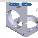
Affordable and easy-to-use CAD software. It enables to open and convert different 2D/3D files, get their dimensions and create section views. CST CAD Navigator supports AutoCAD DWG, DXF, PLT, SVG, CGM, STEP, IGES, STL, SLDPRT, X_T, X_B, and other formats. The software is compatible with Windows, macOS, and Linux. ...

Author CADSoftTools
License Free To Try
Price $79.00
Released 2021-02-25
Downloads 73
Filesize 25.49 MB
Requirements Processor: 2.6 GHz, Display Card: OpenGL 4.0 compliant, Memory: 4 GB
Installation Install and Uninstall
Keywords CAD, CAD software, CAD viewer, 3D viewer, DWG, DXF, STEP, IGES, STL, SLDPRT, X_T, X_B, measuring tools, CAD converter, DWG viewer, STEP viewer, IGES viewer, SLDPRT viewer, X_T viewer, CAD viewer for Linux, 3D viewer for Linux
Users' rating
(7 rating)
CST CAD Navigator for LinuxCADLinux, Linux Console, Linux Gnome, Linux GPL, Linux Open Source
CST CAD Navigator for Linux raster - Download Notice

Using CST CAD Navigator for Linux Free Download crack, warez, password, serial numbers, torrent, keygen, registration codes, key generators is illegal and your business could subject you to lawsuits and leave your operating systems without patches. We do not host any torrent files or links of CST CAD Navigator for Linux on rapidshare.com, depositfiles.com, megaupload.com etc. All CST CAD Navigator for Linux download links are direct CST CAD Navigator for Linux full download from publisher site or their selected mirrors.
Avoid: raster oem software, old version, warez, serial, torrent, CST CAD Navigator for Linux keygen, crack.
Consider: CST CAD Navigator for Linux full version, raster full download, premium download, licensed copy.

CST CAD Navigator for Linux raster - The Latest User Reviews

Most popular CAD downloads

CST CAD Navigator for macOS

1 download

... SLDPRT, SAT, FSAT, SAB, OBJ, BREP, SMT, IPT; Raster formats: PNG, BMP, JPG, JPEG, TIF, TIFF, GIF. MAIN FEATURES: - Import of 2D and 3D CAD files. - Getting information ...

ShareCAD

2.0 download

... STEP, STP, IGES, IGS, BREP, STL, SAT (ACIS); Raster formats: PNG, BMP, JPG, GIF, TIFF, TGA, CAL; Archives: 7z, RAR, CAB, ZIP, BZIP, TAR. ShareCAD enables you to: - open ...

CST CAD Navigator for Linux

1 download

... SLDPRT, SAT, FSAT, SAB, OBJ, BREP, SMT, IPT; Raster formats: PNG, BMP, JPG, JPEG, TIF, TIFF, GIF. MAIN FEATURES: - Import of 2D and 3D CAD files. - Getting information ...

TriSpace

2021.24.3.652 download

... Standard precizion tools (SNAPs and guided mesh); Importing raster images with scaling; Plotting of slope vectors. New features: Photorealistic rendering of the 3D model; Photorealistic rendering of the ...

QGIS

3.36.1 download

... Open Source Software (FOSS). QGIS supports vector, raster, and database formats and lets you browse and ... data viewing needs. QGIS supports a number of raster and vector data formats, with new support easily ...

QGIS for Linux

3.36.1 download

... Open Source Software (FOSS). QGIS supports vector, raster, and database formats and lets you browse and ... data viewing needs. QGIS supports a number of raster and vector data formats, with new support easily ...

CST CAD Navigator

1 download

... SLDPRT, SAT, FSAT, SAB, OBJ, BREP, SMT, IPT; Raster formats: PNG, BMP, JPG, JPEG, TIF, TIFF, GIF. MAIN FEATURES: - Import of 2D and 3D CAD files. - Getting information ...

CAD Import .NET for Compact Framework

1 download

... DWG/DXF, Windows Metafiles WMF/EMF and a set of raster images (*.bmp,*.jpg, *.jpeg,*.tiff, *.gif); - Viewing HPGL (PLT, ... format; - 2D rotation, printing and zooming for raster images; - 3D rotation, printing and zooming, switching ...

2D Batch Print for AutoCAD DWG, DXF, PLT

1 download

... wide range of file formats representing vector and raster graphics. It provides wide capabilities for filtering drawings and printing settings customization for further 'one click' printing. ...

Thuban for Mac OS X

1.0.1-3 download

... Data Support: Shapefile, PostGIS Layer and OGR # Raster Data Support: GeoTIFF Layer and GDAL # Comfortable Map Navigation # Object Identification and Annotation # Legend Editor and Classification # ...