Photogrammetric image rectification 1.0

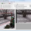
Rectify photos with the help of photogrammetry. So you get a completely level view of one side of a building for example. So you can take the result for measurements of this building. You can export the result as picture or as DXF file. If you take a photo of a rectangle what you get is a trapezoid. The program will rectify the trapezoid so that it will be a rectangle again and the scale of the original object will be ...

Author CAD-KAS GbR
License Demo
Price $39.00
Released 2010-11-07
Downloads 336
Filesize 1.06 MB
Requirements Windows 2000 and newer
Installation Install and Uninstall
Keywords rectify, photogrammetry, photo, restitution, disort, images, photography
Users' rating
(6 rating)
Photogrammetric image rectificationCADWindows XP, Windows Vista, Windows Vista x64, Windows 7 x32, Windows 7 x64, Win2000
Photogrammetric image rectification reality - Download Notice

Using Photogrammetric image rectification Free Download crack, warez, password, serial numbers, torrent, keygen, registration codes, key generators is illegal and your business could subject you to lawsuits and leave your operating systems without patches. We do not host any torrent files or links of Photogrammetric image rectification on rapidshare.com, depositfiles.com, megaupload.com etc. All Photogrammetric image rectification download links are direct Photogrammetric image rectification full download from publisher site or their selected mirrors.
Avoid: reality oem software, old version, warez, serial, torrent, Photogrammetric image rectification keygen, crack.
Consider: Photogrammetric image rectification full version, reality full download, premium download, licensed copy.

Photogrammetric image rectification reality - The Latest User Reviews

Most popular CAD downloads

AutoCAD 2020

2025 download

AutoCAD remains one of the top applications used by professionals to achieve great precision with projects of nearly any type. It encourages usage with incredible offers for student licenses so you ...

Automesher 64-bit

2.4.8 download

... ACIS Text), PLY (Stanford Polygon Format), VRML (Virtual Reality), 3DM (Rhinoceros 3D Model File), SKP (Google SketchUp), STEP (STandardized Exchange of Product), IGES (Initial Graphics Exchange Specification), BREP (Boundary Representation) ...

Amira

2019.2 download

... Movie generation · 3D stereo vision · Virtual reality tools · Tiled screen display · Multi-pipe rendering · Support for tracking · Scripting Customize: · Mesh Option · Microscopy ...

AutoCAD 2010

download

... 3D printing. Nothing takes you from idea to reality faster. Cut Design Time with Parametric Drawing Dramatically slash your design revision time with parametric drawing. By defining persistent relationships ...

Photogrammetric image rectification

1.0 download

... will be restored. This means equal lengths in reality will become equal lengths on the rectified photo. ... in the photo which form a rectangle in reality. You can let the program render an even ...

Energy2D

2.6 download

Energy2D is an interactive, visual simulation program that models all three mechanisms of heat transfer—conduction, convection, and radiation. Students can use it as an inquiry tool to explore and investigate heat ...

Energy2D for Mac OS X

2.6 download

Energy2D is an interactive, visual simulation program that models all three mechanisms of heat transfer—conduction, convection, and radiation. Students can use it as an inquiry tool to explore and investigate heat ...

myHouse

9.0.112 download

... 3D tools of myHouse you can create virtual reality panoramic images that can be explored interactively both ... a look at our QuickTime and VRML Virtual Reality pages ...

AutoCAD 2014

download

... workflow. And with live maps and powerful new reality-capture capabilities, AutoCAD connects your design ideas to the world around you. Design and shape the world around you with ...

AutoCAD 2016

download

... create PDFs that include the geolocation map. Reality computing (enhanced) Enhanced point cloud functionality now includes ... and the capability to display colors by elevation. Reality computing lets you work with point cloud data ...