- Software
- - Graphic Apps
- - CAD
- - hsCADView
hsCADView 4.0.134.2
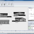
Why buy a full editor, when you just need to take a peek? hsCADView lets you do all things "read only" with a drawing. Visualize and measure intricate CAD drawings in both 2D and 3D. Print, export to PDF/Image/etc., and much more. Take a peek under the hood of a drawing without buying a full design suite. ...
| Author | Hachisoft Corporation |
| License | Commercial |
| Price | $19.99 |
| Released | 2012-11-16 |
| Downloads | 863 |
| Filesize | 35.62 MB |
| Requirements | |
| Installation | Install and Uninstall |
| Keywords | cad, viewer, measure, visualize, dwg, pdf, convert, jpg, image, gif, dxf |
| Users' rating (15 rating) |
Using hsCADView Free Download crack, warez, password, serial numbers, torrent, keygen, registration codes,
key generators is illegal and your business could subject you to lawsuits and leave your operating systems without patches.
We do not host any torrent files or links of hsCADView on rapidshare.com, depositfiles.com, megaupload.com etc.
All hsCADView download links are direct hsCADView full download from publisher site or their selected mirrors.
Avoid: risk tools oem software, old version, warez, serial, torrent, hsCADView keygen, crack.
Consider: hsCADView full version, risk tools full download, premium download, licensed copy.


