- Software
- - Home & Hobby
- - Other
- - ediTrail
ediTrail 1.0
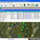
Importation/Exportation: Import/export trails to gpx file. Unlimited number of trails, and TrackPoints. Export to gpx, Excel, PDF, XPS and KML/KMZ. Data table: Very flexible data table that allows sorting by columns, with inheritance of data, attributes, etc. Presentation on map: View on map in accordance with the active trail, which comes from providers of maps, as in 'Satellite' mode (photos, orthophotos, etc), as 'Map' mode, (Topographic map, street maps, etc). Digital Terrain Model, DTM: I have downloaded all the files, patches, with elevations of a point every 90 metres from around the world and 30 meters for United States, (DEM, digital elevation model), taken by the 'Shuttle Radar Topography Mission', SRTM. I've put all these files on a dedicated server that can access all from anywhere. And with these files is created the DTM and contouring map of that we are seeing on the map in that moment. Longitudinal profile: Profile with direct and reciprocal relationship with the TrackPoints and WayPoints of the active trail. Edition of trails: It's the tool more powerful has the program and, in fact, was so started the program, to be able to edit my trails. You can create, modify, join, split and delete trails graphically. And the best is that this is done graphically on the map by clicking on the trail in one way easier. Display/management of photographs: I have created an images viewer so that you can see them easily and rotate them if necessary. The photograph can be 'Drag and drop' on table, easily. AutoCAD/Bricscad/ZWCad: I have created the program, also, so that works within these three platforms. Thus, you can draw the trails, waypoints, digital model, map displayed, contouring and cloud of points, inside the CAD, with entities of CAD. Thus, you can have your trail in UTM XYZ WGS84 coordinates, with what that represents, thus you can include new maps of any active WMS service, (Warehouse Management System), and above all, with CAD tools.
| Author | Aplicaciones Topográficas S.L. |
| License | Freeware |
| Price | FREE |
| Released | 2014-11-07 |
| Downloads | 210 |
| Filesize | 27.05 MB |
| Requirements | Desktop application, MIcrosoft operating systems, 32&64 bits |
| Installation | Install and Uninstall |
| Keywords | Trail, Route, GPS, gpx, geographical, latitude, longitude, utm, elevation, photo, Track, Way Point, Track Point, hiking, biking, cycling, map, land, terrain, surveying, DTM, D.T.M., digital terrain model, AutoCAD, BricsCAD, CAD, draw, points cloud, contouring, triangulation |
| Users' rating (23 rating) |
Using ediTrail Free Download crack, warez, password, serial numbers, torrent, keygen, registration codes,
key generators is illegal and your business could subject you to lawsuits and leave your operating systems without patches.
We do not host any torrent files or links of ediTrail on rapidshare.com, depositfiles.com, megaupload.com etc.
All ediTrail download links are direct ediTrail full download from publisher site or their selected mirrors.
Avoid: oem software, old version, warez, serial, torrent, ediTrail keygen, crack.
Consider: ediTrail full version, full download, premium download, licensed copy.