TatukGIS Viewer 5.87.0.3409
TatukGIS Viewer: A Comprehensive GIS Solution for Professionals and Enthusiasts
TatukGIS Viewer, developed by TatukGIS, stands out as a robust and versatile Geographic Information System (GIS) application designed to cater to both professionals and GIS enthusiasts. This free, feature-rich software offers an impressive array of tools and functionalities that make it an indispensable asset for anyone involved in spatial data analysis, mapping, and visualization.
At its core, TatukGIS Viewer is built to handle a wide range of GIS data formats, ensuring seamless integration and compatibility with various data sources. Whether you're working with shapefiles, GeoTIFFs, or complex spatial databases, this software provides the flexibility needed to manage and analyze your geospatial data efficiently.
One of the most notable features of TatukGIS Viewer is its intuitive and user-friendly interface. The software is designed to be accessible to users of all skill levels, from beginners to seasoned GIS professionals. The clean and organized layout allows for easy navigation and quick access to essential tools, making the learning curve remarkably gentle.
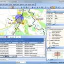
TatukGIS Viewer excels in its ability to render high-quality maps and spatial data visualizations. The software supports advanced rendering techniques, including anti-aliasing and transparency, which result in crisp and visually appealing maps. Users can customize the appearance of their maps with a variety of styling options, ensuring that the final output meets their specific needs and preferences.
In addition to its powerful visualization capabilities, TatukGIS Viewer offers a comprehensive suite of analytical tools. Users can perform spatial queries, measure distances and areas, and conduct buffer analyses with ease. The software also supports advanced geoprocessing tasks, such as overlay operations and spatial joins, enabling users to derive meaningful insights from their data.
TatukGIS Viewer is also notable for its robust support for coordinate systems and projections. The software includes an extensive library of predefined coordinate systems and allows users to define custom projections, ensuring accurate and reliable geospatial data representation.
Collaboration and data sharing are made easy with TatukGIS Viewer. The software supports exporting maps and data to various formats, including PDF, JPEG, and PNG, making it simple to share your work with colleagues and stakeholders. Additionally, the software's compatibility with web mapping services (WMS) and web feature services (WFS) allows for seamless integration with online GIS platforms.
Performance is another area where TatukGIS Viewer shines. The software is optimized for speed and efficiency, capable of handling large datasets and complex analyses without compromising on performance. This makes it an ideal choice for users who require a reliable and responsive GIS solution.
In summary, TatukGIS Viewer by TatukGIS is a powerful, user-friendly, and versatile GIS application that offers a comprehensive set of tools for spatial data analysis, mapping, and visualization. Its support for a wide range of data formats, advanced rendering capabilities, and robust analytical tools make it an excellent choice for both GIS professionals and enthusiasts. Whether you're looking to create stunning maps, perform in-depth spatial analyses, or simply explore geospatial data, TatukGIS Viewer provides the functionality and performance needed to achieve your goals.
| Author | TatukGIS |
| License | Freeware |
| Price | FREE |
| Released | 2025-07-01 |
| Downloads | 256 |
| Filesize | 187.00 MB |
| Requirements | |
| Installation | Instal And Uninstall |
| Keywords | raster image Viewer, GIS editor, GIS map, viewer, graphic, view, edit |
| Users' rating (60 rating) |
Using TatukGIS Viewer Free Download crack, warez, password, serial numbers, torrent, keygen, registration codes,
key generators is illegal and your business could subject you to lawsuits and leave your operating systems without patches.
We do not host any torrent files or links of TatukGIS Viewer on rapidshare.com, depositfiles.com, megaupload.com etc.
All TatukGIS Viewer download links are direct TatukGIS Viewer full download from publisher site or their selected mirrors.
Avoid: oem software, old version, warez, serial, torrent, TatukGIS Viewer keygen, crack.
Consider: TatukGIS Viewer full version, full download, premium download, licensed copy.